Drone processing on cloud GPUs. Survey tools in the browser.
Send a flight from AutoTerra to our GPUs, mark ground control and check the adjustment in the browser, then measure, map and share the site with the people who need it — no licence at their end. Every result comes back to your desktop project.
No GPU workstation needed. Charged by GPU time, never per image or per hectare.
From the flight to a reviewed site, without a GPU on your desk
One drone survey, 214 photos and four control points, followed through AutoTerra Cloud.
From AutoTerra
Pick the outputs, see the credit quote, and upload. Photos are compressed losslessly on the way.
GCPs in the browser
After keypoints, mark the control on image chips and check the residuals.
Measure and map
Ortho, relief and contours; profiles, sections, volumes, 3D and digitising.
Back to the desktop
Download the results and features into the same project for CAD and reports.
A quote before you upload, a refund for what you don't use
Process on Aero Cloud shows what will be sent, which stages will run and what each one costs in credits. Each stage holds its quote when it starts, is charged only for the GPU minutes it uses, and the rest is refunded.
- Keypoints, dense cloud, textured mesh, orthomosaic and DSM, ground and DEM
- Photos sent as lossless JPEG XL, about 20% smaller, restored exactly in the cloud
- Choose the queue; the Standard queue starts within a minute
- Processing on your own computer stays free of credits
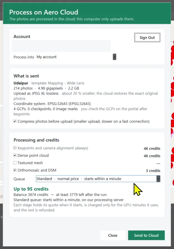
214 photos, 4.98 gigapixels: quoted at up to 95 credits before sending.
Mark ground control in the browser, then check the fit
Once the photos are aligned, the job waits for your control. Each point opens as a set of image chips, so you click the target centre on the photos that see it. The adjustment then fits the model to your surveyed coordinates.
- Stage status for every step of the job, with its credits
- Magnified chips for placing each mark
- Residuals per control point in the Quality tab
- Or continue without GCPs, placed by the photos' GPS
Stage status, GCP marking on image chips, then the residuals.
Orthomosaic, relief and contours on one map
The Map tab layers the orthomosaic over a basemap with the photo positions, then switches to elevation relief, hillshade and contours of the same ground. Contour interval, labels and colours are set in the browser.
- Orthomosaic, DSM and DEM relief, hillshade
- Contours from the bare-ground DEM, styled in place
- Photo positions and survey footprint over a basemap
Orthomosaic to relief and contours on the same site.
Trace a road, read it by chainage
Draw a profile over the orthomosaic and the elevations come from the surface you choose. The profile viewer links the plan, the station table and the graph. Cross-section sets follow the same line at the interval and widths you set.
- Profiles compared across DSM and bare-ground DEM
- Cross-section sets with interval and left and right widths
- Distance, area and spot heights, saved with the project
Profile along the road, then a cross-section set on the same line.
Cut and fill inside a boundary, levels on a grid
Trace a boundary, choose the surface and the base, and read cut and fill separately. Spot levels sample a regular grid over a saved area for site teams and checks.
- Cut and fill against a chosen base, with area
- Spot-level grids at the spacing you set
- Comments pinned to the map for whoever reviews it next
A volume boundary with its cut and fill, then a spot-level grid.
Orbit the surface and the point cloud
The 3D view shows the ground surface by elevation or the dense cloud in image colour, with camera positions, measurements and comments in place. An inset plan keeps track of where you are.
- Elevation-coloured surface and RGB point cloud
- Camera positions, measurements and comments in 3D
- Digitised lines draped on the terrain
Surface by elevation, the RGB cloud, and the survey overlays in 3D.
Capture features in 2D and 3D, take them home as GIS
Create feature classes for plots, roads or anything else, then trace them over the orthomosaic. Lines can take their heights from the ground surface. When you download the results, the features come into the desktop project as GIS tables.
- Point, line and polygon classes with snapping
- Heights from the surface at every vertex
- Features downloaded as GIS tables with their attributes
Plot polygons and road lines traced, then checked in 3D.
Not only drone jobs — put any project online
From AutoTerra Pro upward, upload whole desktop projects: point clouds, surfaces, rasters, alignments with profiles and cross-sections, and drawings. An update sends only what changed, and keeps the measurements, comments and shares already on the project.
- Clouds, surfaces, rasters, alignments and drawings from the desktop
- Updates send only the changed files, nothing starts again
- Drawing edits made online come back to your desktop project
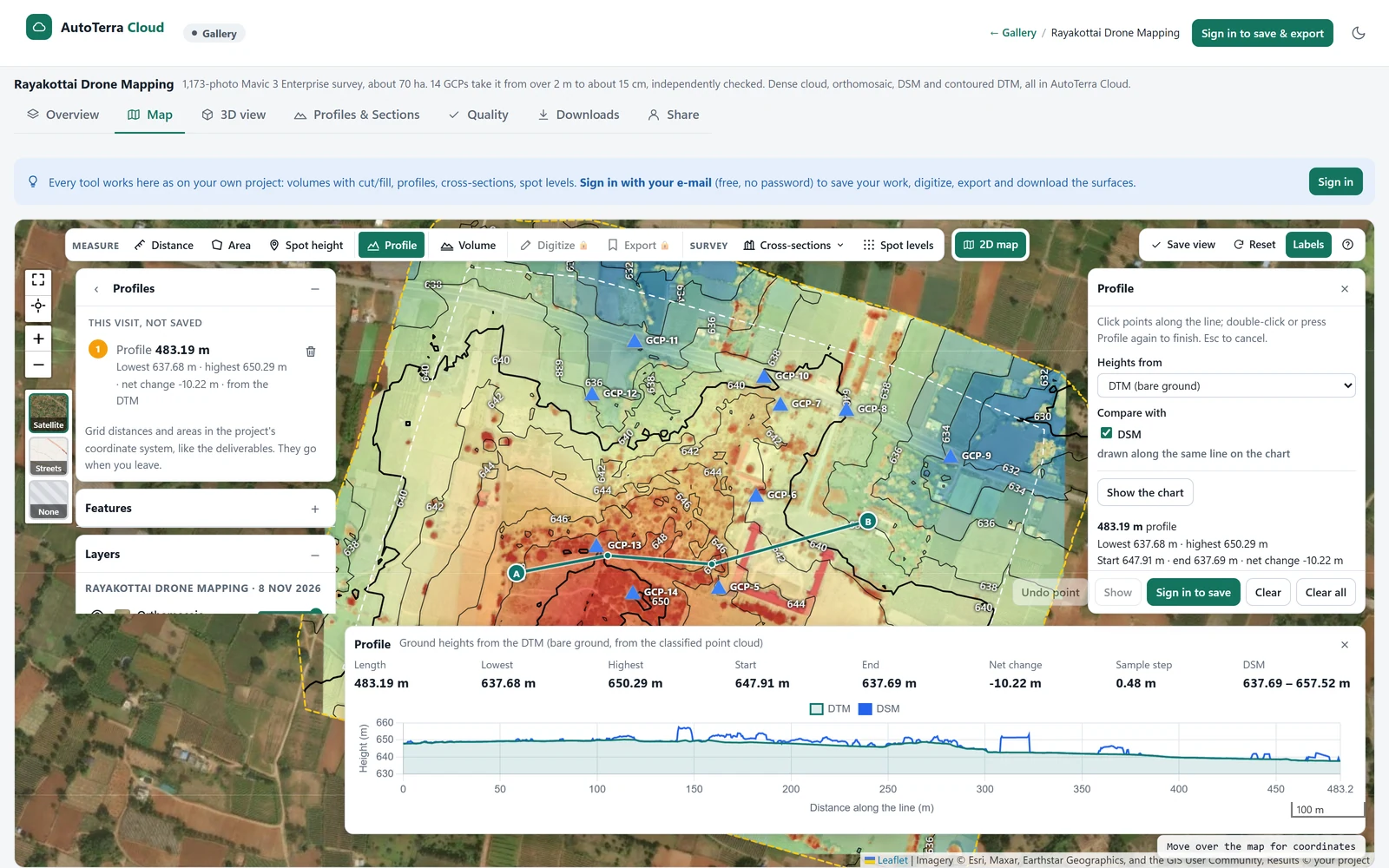
A shared survey: orthomosaic with relief and contours, and a 483 m profile.
Invite the people who need the survey. They need no licence.
Engineers, contractors, consultants and the site office open the project in a browser, measure what they like and pin comments where the question is. Sharing is by e-mail invitation to named people — no anonymous links, so you always know who holds the survey.
Named, by e-mail
Up to 20 addresses at a time. Each gets a personal link tied to their own address.
- No AutoTerra licence, no password
- One click from the e-mail, on any device
- Listed on their own “Shared with me” page
Only what you tick
Choose per invitation what the share includes; everything else stays yours.
- Orthomosaic, heights and 3D, flight and GCPs
- Saved measurements, volumes, drawings, quality report
- Guests never download files
You decide, and can stop it
Access runs until you end it, or expires on its own after 7, 30 or 90 days.
- Revoke ends a person’s access at once
- See who opened it, when, and how often
- Resend the same link, or change what they see
A note pinned where the question is
Instead of a screenshot pasted into an e-mail, the comment sits on the spot it is about — on the map, in 3D, at a chainage along an alignment, or attached to one of your saved measurements. People invited to view and comment add them; everyone else reads them.
- Pinned in 2D or 3D, kept with the project
- A reviewer can measure, then keep that measurement as a comment
- On a road project, comments list by chainage under the alignment
- Click one on your own map to fly straight to it
What a reviewer gets: the survey, the tools to check it, and nowhere to break it — drawings and saved items are read-only.
AutoTerra Aero Cloud, end to end

Cloud photogrammetry and browser survey tools2:24 · highlights of the full workflow
Cloud comes with your AutoTerra seat
AutoTerra Aero
Drone processing on your computer and on Cloud, with yearly credits. Ground, DTM and contours. No sections, volumes or whole-project upload.
See detailsAutoTerra Pro Aero
Everything in Aero, with yearly credits, plus sections, volumes, ML classification and whole-project upload to Cloud.
Start free trialCloud credit packs
$200 for 2,000 and $430 for 5,000 — the larger the pack, the lower the rate. Bought credits never expire, and your free ones are always spent first.
Open AutoTerra CloudPrices exclude GST or local taxes. 3-month to 5-year terms. Multi-seat pricing on request. A part-year term earns its share of the free credits. AutoTerra Pro and Pro Spatial include project upload and sharing; drone processing on Cloud needs Aero or Pro Aero.
Before you send the first job
How is a job charged?
In credits, about one per GPU-minute. You see the quote before sending; each stage holds its quote when it starts, is charged for the minutes it uses, and the rest is refunded.
Do we still need AutoTerra on the desktop?
Yes. Jobs start from AutoTerra, and the results come back into the desktop project for CAD, contours, sections and final volumes.
Can someone see the survey without a licence?
Yes. Invite them by e-mail and they get a personal link: one click signs them in, and the project opens in any browser. No licence, no password, and no downloads — they see what you ticked, and you can revoke it at any time.
Can we keep processing on our own computers?
Yes. Cloud is optional. Processing on your own computer uses no credits and has no per-image fees.
Do the free credits cover real work?
Aero grants 1,000 credits a year and Pro Aero 2,000 — roughly that many GPU-minutes. Free credits are spent before bought ones, and unused ones expire at the end of the subscription year. Packs start at $60 for 500 and never expire.
How much storage is included?
2 TB with Pro Aero, 1 TB with Aero, 1 TB with Pro Spatial and 100 GB with Pro — a standing allowance for as long as the subscription runs, not a yearly one. Uploading results or whole projects costs no credits within it, and measurements, comments and shares never count against it. Storage packs add 1 TB for $35 a month when you need more.
How long do projects stay on Cloud?
A project is kept for 90 days after its last activity, with an e-mail warning seven days before anything is removed. Switch a project to Keep and it is exempt from that — its files simply count against your allowance. If a subscription lapses you get 30 days read-only, after which projects are paused rather than deleted, and renewing restores everything, bought credits included.
Send your next flight to AutoTerra Cloud
Start the 30-day Pro Aero trial, or book a demo and we'll run one of your flights through Cloud with you.