Classify the cloud, check it in section, deliver the ground.
Classification, machine learning, DTM and feature extraction, with CAD and engineering in the same seat.
The trial includes ML classification and the Powerline and Tunnel modules.
From raw strips to deliverables your QC team will pass
Any scanner
LAS, LAZ, E57, PLY, PTS, PTX and ASCII, plus RIEGL formats. Aerial, mobile, terrestrial, handheld or drone.
Rules and ML
Saved task lists run ground, noise, vegetation and objects. Then ML finishes what you've trained it on.
In section
Walk the cloud in section, fix by fence or brush, and review what was detected.
Client formats
Classified LAS, DTM and DSM GeoTIFFs, contours, sections and GIS layers.
See every class, and every mistake, in the section
Plan, 3D and section views stay in step, so you can see what each routine did and correct it on the spot. Edits go straight back to the cloud.
- Ground, low, medium and high vegetation, buildings, water and noise
- Road, rail, wires, towers, bridges, kerbs and barriers
- Separate settings for scanner type, terrain and vegetation density
- Fence and brush edits, with point counts and height range for each class
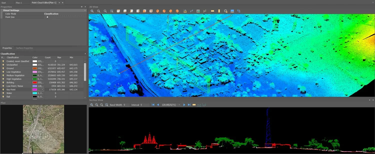
Class table, 3D view, plan and section, all on one aerial LiDAR dataset.
Models that learn from your corrections
Your clients' terrain isn't in someone else's demo. Correct the cloud as you normally would, train a model from those corrections, and use it on the next job. Models stay in your own library.
- Train from points you've already checked
- Classify with your models, then review as usual
- Runs on your computer, with no per-point charge
- Train object detection from objects you've captured
Set it up once, then run the whole project
Save the routines as a named task list for each kind of job. Split large projects into tiles and run the list across them, in parallel, and open any tile to check it.
- Named task lists you can reuse across projects
- Clouds up to 1 billion points; larger projects through tiles
- Ground, vegetation, objects, noise and key-points run on tiles
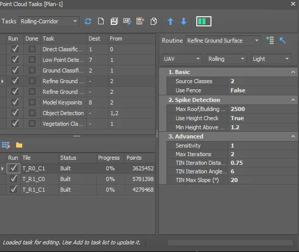
A saved corridor task list, ready to run across tiles.
A bare-earth model that respects the terrain
Ground classification works from a TIN you can tune, including for steep faces and drone clouds. Build the surface in the same window and check it against the cloud.
- Ground presets by scanner and terrain, with every setting open to you
- DTM, key-points, contours and sections from the classified cloud
- Volumes and earthwork reports in the same seat
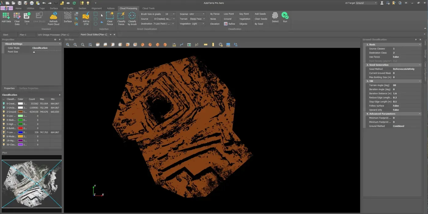
Ground classified on a benched quarry from a drone cloud.
From points to lines, assets and GIS layers
Pick a start and let the tracker follow the road, section by section. Detected objects go to a review list, where you accept them and send them to CAD or GIS.
- Road centrelines, edges, kerbs and barriers
- Centre, edge and dash road-marking lines
- Poles, signs and building footprints
- Trees and stem inventory with a stand report
Buildings, trees and towers, cut clean

One section from the dataset above. Each class has its own colour, so an error shows up at a glance.
Add the work you specialise in
What you hand over
Choose by what you classify
AutoTerra Spatial
Ground, noise, low points and key-points on clouds up to 25 million points, with DTM and contours. No sections or volumes.
See detailsAutoTerra Pro Spatial
Up to 1 billion points. All classes, ML, feature extraction, tiles, task lists, sections and volumes. Upload projects to Cloud to share them.
Start with the Pro Aero trialAutoTerra Pro Aero
Everything in Pro Spatial, plus drone photogrammetry and Cloud credits. Available as a 30-day trial.
See the drone workflowPrices exclude GST or local taxes. 3-month to 5-year terms.
Before you start
Which formats and scanners work?
LAS, LAZ, E57, PLY, XYZ, PTS, PTX and delimited text. RIEGL RDBX and RXP load when RIEGL's own libraries are installed on the computer.
How big a cloud can it handle?
Pro Spatial and Pro Aero open clouds up to 1 billion points. Anything larger goes through a tiled project, and task lists run across the tiles.
Will ML work on our data?
Train it on your own corrected clouds, and try that on your data during the trial. It doesn't replace QC: you still review the result in section.
Can we check it against our current software?
Yes. Send a tile you've already delivered and we'll classify it live on a demo, so you can compare the results directly.
Bring a tile you've already delivered
Compare the classification, the DTM and the time. Start the 30-day trial, or we'll run it with you.